GENERAL LAND OFFICE RECORDS FOR GENEALOGY

. Omaha, 1886. Map. https://www.loc.gov/item/98688509/.
General Land Office (GLO) records at the U.S. Department of the Interior Bureau of Land Management (BLM) are wonderful if you happen to have an ancestor who purchased public land. The website is https://glorecords.blm.gov/. They have over 5,000,000 land title records starting in 1788. Not every single land title record will be on this site, but it is a worthwhile search if your ancestor’s land does happen to be mentioned.

There is a good description of the types of records that are on the BLM-GLO site on their home page. Land patents on this site include cash entry (individuals paying cash for the land), homestead (1862-1976 – 160 acres issued to those who would “improve” the land), and military warrants (land issued to veterans for their military service). Keep in mind that this site is for the transfer of federal land to individuals, not for land sales between individuals. There are survey plats, field notes, and land status records, along with a land catalog that enables you to search for your ancestor’s land.
Be sure to read the Reference Center section found at the top of the page for information about the records on this site. The BLM only has records for states that were surveyed by township and range and not by the older metes and bounds survey method; therefore, this website does not have records for the original 13 colonies and the states of Kentucky, Maine, Tennessee, Vermont, Virginia, West Virginia, Hawaii, and Texas.[1]
Clicking on the Search Documents tab takes you to a screen with three options: Search Documents by Type, Search Documents by Location, and Search Documents by Identifier. Depending on the information that you have on your ancestors’ land, you can choose any of these to search.
Searching by Identifier is useful if you have very specific information about your ancestor’s land (serial number, survey ID, etc.). Searching by location can give you a list of your ancestor’s FAN club (friends, associates, and neighbors) by showing everyone in the township that obtained land directly from the Federal Government. For example, if I wanted to see who were the original recipients of one of the townships in Yuma County, Colorado, I could look for Yuma County on the map and right-click on the area in which I am interested. In the following example, I chose Main Street in Wray, Colorado. I right-clicked on that area and the township appears in the left search box under Mapped Townships. The information given is Colorado, 6th prime meridian, Township 1N, Range 43W.

Clicking on the Search button reveals 15 pages of people who acquired land from the Federal Government in this township from 1879 until 1920. The list can be sorted by any of the columns. Here, it is sorted by name (default):
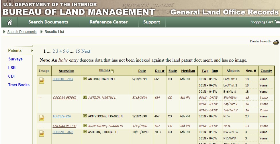
You can click to view the information on the land for each individual. Some of the records will have images and some will not.
If you would like to see if your specific ancestor had acquired land, you can use the feature Search Documents by Type. This search engine accepts wildcards and there is a search help on this website in the reference section.
I was curious about one of my husband’s ancestors who farmed in Pawnee County, Nebraska. I typed in the state, county, and his name – John Curtis.
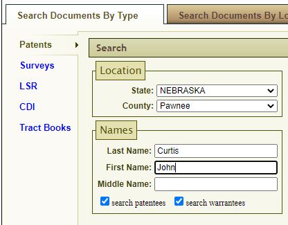
There was one John Curtis in the search result, and after reviewing the information, I found him to be the correct ancestor.

I was able to read the patent details and view the patent image. (This can take a while to load.) I can download or purchase a certified copy of the patent image.

I now know that the claim of John Curtis was established for the “North West quarter of Section twenty seven, in Township three North of Range nine East”. This information can be put into Google Earth and so you can see exactly where this homestead was located. An easy way is to go to the website https://www.earthpoint.us/townshipssearchbydescription.aspx and key in the coordinates and click on “Fly To On Google Earth”. A screenprint of this website is shown:

If you want to view the place on Google Earth Pro, you can download the .kml file that pops up in a separate window after you click on “Fly To”. Once you are on Google Earth Pro (a free download from Google), you can do a File – Open to choose the .kml file and you will “fly” to the place on the map where your ancestor lived. The section in which his homestead is located is framed in purple on the map below. From here, you can determine the NW ¼ of section 27 and see what is now there. (It is still a farm.)

There is still more to discover with the land patent search. If you click the Related Documents tab, you can see several more documents to look at.

The other Curtis’ mentioned here could be family members. The other men may be associates. A search by location, pinpointing this township, may show other people that could be neighbors and associates. The original survey of the township can be found on the left-hand side by clicking on the word “Surveys”.
This is a valuable tool for research, and if you enjoy maps, this can also be fun. Check this website out and remember – Search Smart!
Sara Martin
[1] Tom Huber, A Location Guide to the General Land Office (GLO) Survey Plats (https://www.lib.niu.edu/1999/il9904232.html : accessed 13 January 2021, para. 4.
